Cambrian Limestone Aquifer Faces Accelerated Drying
Aquifer Depletion is becoming a critical concern as the Cambrian Limestone Aquifer (CLA) faces alarming rates of drying.
The increasing water losses observed since 2014 have prompted satellite analyses revealing a drastic decline in water levels.
This article delves into the factors contributing to the aquifer’s rapid depletion, exploring the impact of irrigation licenses, concerns surrounding hydraulic fracturing in the Beetaloo Basin, and the urgent need for improved water management strategies to mitigate further risks to this vital resource.
Accelerated Drying Seen From Space
Satellites are now witnessing an unprecedented decline in the Cambrian Limestone Aquifer (CLA), a stark contrast to its formerly stable state from 2002 to 2013. These visible water losses from space mark a significant downturn in this pivotal water resource, raising considerable concern.
Since the approval of large irrigation licenses in Mataranka in 2013, the rate of water extraction has surged continuously, leading to dramatic depletion.
Satellite-derived imagery powerfully underscores 2021 as the year marking the lowest storage level ever recorded.
Consequently, this decline correlates with the development of hydraulic fracturing sites in the Beetaloo Basin, making the scenario even more dire.
The recovery time for the aquifer has significantly increased, now taking over 15 months, compared to just under five months in 2014. These satellite observations stress the immediate need for urgent regulation to prevent over-exploitation of the aquifer further.
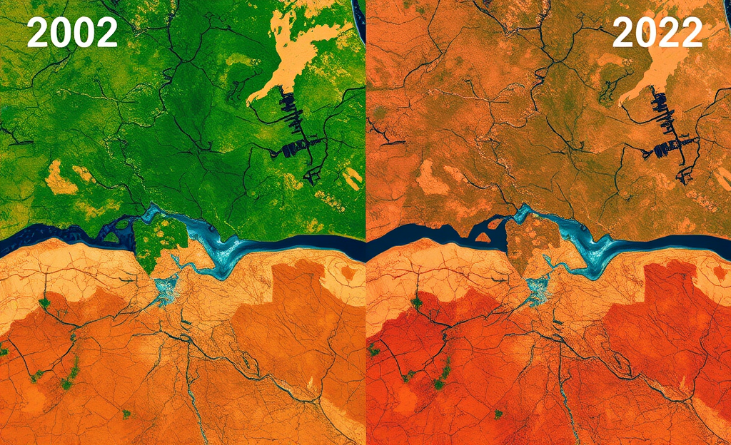
From Stability to Steep Decline (2002–2022)
From **2002** to **2013**, satellite data reveal the Cambrian Limestone Aquifer (CLA) maintained a stable water level, its reserves undisturbed.
However, a pivotal transformation begins in **2011**; the signs of change become evident.
In a deluge of events, water levels plummet.
By **2016**, an alarming **11% drop becomes noticeable**.
This figure marks the growing concern for the aquifer’s future.
The data, tracked meticulously over these years, embody the caveat of imbalances introduced into the ecosystem.
An abrupt aquifer contraction is underscored as each year unfolds—a relentless pace ensues from **2011**.
The newfound capacity for satellite technology to relay these shifts stands paramount, offering a broader understanding of freshwater depletion, as emphasized by the Griffith University research detailing these precise declines.
The stark pattern laid bare from space serves as a sobering reminder of humanity’s impact.
Lengthening Recovery Times and the Peril of Over-Exploitation
Recovery times for the Cambrian Limestone Aquifer have worsened dramatically from 2014 to 2021, with a significant extension from less than five months to well over fifteen months.
This exacerbating trend mirrors the increased demand and over-extraction, posing severe threats to the aquifer’s sustainability.
Below is a concise overview of the recovery progression:
| Year | Recovery Time |
|---|---|
| 2014 | 4.7 months |
| 2018 | 10.2 months |
| 2021 | 15.3 months |
The increasing recovery times underscore the mounting over-exploitation concerns, as observed by satellite data.
With water extraction surging post-2013 after the approval of large irrigation licenses in Mataranka, the regional water resources started depleting at an alarming rate.
Implementing tighter regulation becomes essential to counter these risks.
Additionally, satellite monitoring emerges as a crucial tool in formulating effective management strategies, enabling authorities to make informed decisions and prevent irreversible losses.
Extraction Pressures: Irrigation and Hydraulic Fracturing
The Cambrian Limestone Aquifer (CLA) experienced significant stress due to increased extraction activities beginning in 2013. This period saw a surge in irrigation licenses around Mataranka, coinciding with the expansion of hydraulic-fracturing projects in the Beetaloo Basin.
Satellite imagery revealed a decrease in water levels correlating spatially with these activities.
As a critical water source, the CLA can’t sustain the pressures from both agricultural and industrial demands.
- Mataranka irrigation licenses (2013) — rapid uptick in permitted withdrawals
- Beetaloo Basin fracking activity — additional regional demand and potential contamination pathways
The overlap between extraction locations and declining water regions is stark.
ResearchGate’s insights on CLA support these findings, indicating
In conclusion, addressing the challenges of aquifer depletion requires urgent action and regulation to protect the Cambrian Limestone Aquifer.
By leveraging satellite monitoring, we can develop effective water management strategies that ensure the sustainability of this crucial water source.


0 Comments